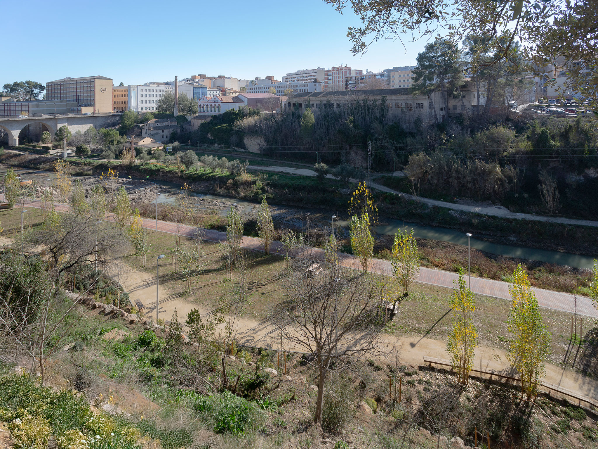
Síntesi Arquitectes, Sari Calatayud and Rafa Mira propose a linear layout that follows the riverbed, distinguishing flood-prone areas from non-flooded areas based on elevation. The park begins in the east with a reception area and a plaza linked to the Matadero building, facilitating the connection between both sides of the river. In the western part of the park, planted steps have been laid out to adapt to the slope of the land, as well as a platform protected from flooding. The flood-prone area, located on the riverbank, consists of a riparian forest and a path.
The materials chosen are based on their ability to be located in areas susceptible to flooding or not. This is the case of the masonry walls that delimit certain areas. The project also includes a polygonal viewing platform made of the same material, planted slopes, rockeries, tiered platforms, and a staircase that connects the different levels of the park. All of these elements respect the terrain and weather conditions, establishing a harmony with the river and enhancing the surrounding environment.
The project was awarded in the 2025 edition of the La Casa de la Arquitectura Awards, in the Public Action section.
"Les Mamàs Belgues" by Síntesi Arquitectes, Sari Calatayud and Rafa Mira. Photography by Víctor Sanchis.
Description of project by Síntesi Arquitectes, Sari Calatayud and Rafa Mira
In September 2019, torrential rains associated with a DANA caused the Clariano river to overflow its banks at Canterería street in Ontinyent, forcing the rescue of 40 residents and the evacuation of another 150. Mediterranean phenomena are becoming increasingly extreme, frequent and prolonged due to climate change, which makes it necessary to reduce the vulnerability of populations and exposure to risks, respecting riverbeds and their flood plains.
This emergency situation is the trigger that coordinates the collaboration between local, regional and state administrations to gather resources and address a comprehensive resilience strategy that is developed at different management and technical levels within the EDUSI Strategy, addressing the acquisition of buildings and relocation of neighbours, the demolition of houses, the consolidation of the slope and the execution of the flood park.
The intervention is part of the landscape and urban regeneration of the riverbed, favouring the connection between neighbourhoods separated by the natural barrier of the river, in a city that for decades has turned its back on it, dotted with heritage vestiges resulting from the disappearance of the industrial fabric linked to the watercourse.
The park has a markedly linear layout, delimited between the riverbed and the slope behind it, its two ends linking up with the urban fabric: to the east, the square linked to the slaughterhouse and the reception of the footbridge under construction that will connect both banks of the river; to the west, a series of vegetated steps that adapt the difference in level between the street and the raised platform protected from floods. A riverside wood and natural meadow extend at flood level, crossed by a path that invites you to stroll and discover different views of the riverbed and the city from a subtle elevation that dynamises the passage between the trees.

The masonry wall that constituted the enclosure and containment of a demolished industry between the raised platform and the flood zone is incorporated into the design and serves as a guide to extend its layout in the same tradition of the fanning walls. Thus, the masonry forms a geometrically designed belvedere, encasing the upper platform like a watchtower. This same solution is extended as a scenic backdrop and protection for the caves excavated in the hillside, acting as a barrier against the landslides from the slope behind.
The elevated platform, which is less exposed to flooding, has the character of an urban park as it concentrates a greater variety of equipment and native plant species, as well as being visually delimited, facilitating free play and family recreational use.

Vegetated slopes, rockeries, tiered platforms and a staircase linking the two levels of the intervention, diluting their transition. Permeable paving, polygonal benches that delimit alcoves, vegetation that protects slopes, stone walls, intentional sobriety of materials and compositional elements.
Understanding and respecting that the riverbed, although sporadically, belongs to the river, allows the river dynamics to coexist with the reward of gaining natural space for the city.