


The land master plan, jointly designed by EFFEKT, OMA, and LOLA, is framed by several infrastructural and topographic barriers, such as the river, railways, a main road, a viaduct and a dam.
A sloping terrain will connect the riverbank to inner areas, creating dynamic topography over existing rail tracks, with a distinctive landscape design that will integrate green public spaces, leisure areas, and commercial hubs. The nature-friendly boulevard will link Waterkant to Feyenoord City’s tidal park, forming a vibrant destination. Improved connectivity between Rotterdam’s north and south will be achieved through a new bridge, Stadionpark station, and enhanced pedestrian and cycling routes.
This adaptable framework supports a diverse mix of structures, including residential towers, offices, a school, healthcare facilities, an Urban Sports and Street Culture Campus, and other social facilities that foster urban life.
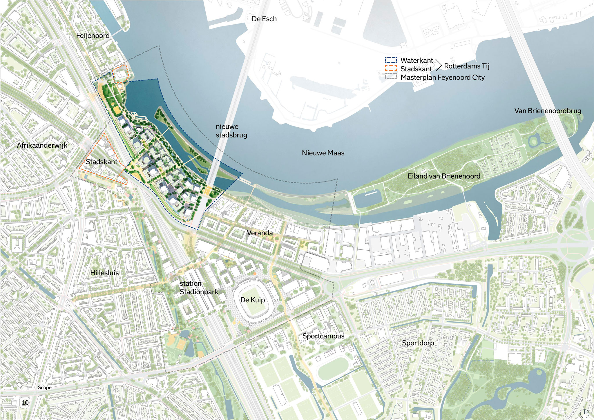
Masterplan Feyenoord City, Waterkant and Stadskant by EFFEKT, OMA and LOLA.
Project description by OMA
The Waterkant is part of the Feyenoord City masterplan, developed after the decision to pause construction of the new Feyenoord Stadium. Jointly designed by EFFEKT, OMA, and LOLA, the project introduces a new approach to urban planning for a high-density neighborhood. Situated on the Nieuwe Maas riverbank – adjacent to the planned bridge and overlooking a future tidal park with recreational water features – the Waterkant will become a vibrant urban center, integrated with its architectural and social surroundings. Public spaces, landscape elements, and buildings will combine to create a distinctive waterfront destination for residents and visitors from Rotterdam and beyond.
The site is framed by several infrastructural and topographic barriers, including the river, railways, a major road, a viaduct, and a dike. To overcome these challenges, a new terrain has been constructed to unify these varying heights, resulting in a continuous and integrated topography. This car-free, green landscape forms a new public outdoor space for the neighborhood, featuring a promenade with walking and cycling paths, leisure areas, and parking concealed beneath the terrain. Green corridors weave through the district, connecting to existing greenery.

The design team has developed a flexible framework of streets and urban spaces atop this terrain, capable of accommodating high-density development. By strategically positioning taller buildings and reducing the scale of building masses, the Waterkant maintains a human scale in its public areas and streets despite its density. Generous sunlight reaches both residents and visitors. This adaptable framework supports a diverse mix of structures, including residential towers, offices, a school, healthcare facilities, an Urban Sports and Street Culture Campus, and other social facilities that foster urban life. The development is guided by principles that prioritize high-quality public spaces and residential environments with favorable living conditions.


